
The Himalayan Blunder
Introduction:
The Indian Himalayan Range (IHR), comprising 11 States and two Union Territories, had a decadal urban growth rate of more than 40% from 201 1 to 2021 .Towns have expanded, and more urban settlements are developing unsustainably. Almost all Himalayan towns, including State capitals, struggle with managing civic issues. For example, cities like Dehradun, Nainital, Srinagar, Guwahati, Shillong, and Shimla, as well as smaller towns, face significant challenges in managing sanitation, solid and liquid waste, and water. City governments are short of human resources by almost 75% and beset with rampant corruption. Cities continue to expand into the peripheries, encroaching on the commons of villages. Srinagar and Guwahati are examples of such expansion, leading to the plundering of open spaces, forest land, and watersheds. In Srinagar, land use changes between 2000 and 2020 showed a 75.58% increase. Water bodies have eroded by almost 25%, from 19.36 square kilometers to 14.44 square kilometers. These areas have been taken over by built-up real estate, increasing from 34.53 square kilometers to 60.63 square kilometers, a rise from 13.35% to 23.44% of the total municipal area. Nearly 90% of the liquid waste enters water bodies without treatment. Over the past few decades, tourism in the IHR has continued to expand and diversify, with an anticipated average annual growth rate of 7.9% from 2013 to 2023. Current tourism in the IHR often replaces eco-friendly infrastructure with inappropriate, unsightly, and dangerous constructions, poorly designed roads, and inadequate solid waste management, which leads to loss of natural resources damaging biodiversity and ecosystem services. The high costs of urban services and the lack of corridors place these towns in a unique financial situation. Current intergovernmental transfers from the center to urban local bodies constitute a mere 0.5% of GDP; this should be increased to at least 1 % of the GDP. Uttarakhand and Himachal Pradesh in the Himalayan region are extremely eco-sensitive, hundreds of people lose their lives due to landslides along with destruction worth crores of rupees. The h ill states are very vulnerable for example, the total area of 55,673 square kilometers of Himachal Pradesh, 38,249 sq. km area comes under high risk and 4,461 square km area comes under very high-risk area for landslides. The number of landslides has increased wildly on account of road construction in the hill states. More than 80 thousand trees have been cut for the highways in Himachal Pradesh and it has led to the reduction in carrying capacity of the area on account of the increasing construction in the tourism sector.A 1 15,000-megawatt power project has been planned in the Himalayan region, extending from Jammu and Kashmir to Arunachal Pradesh and for the restoration of the ecosystem all such plans needs to be dropped immediately. Due to the impact of these power projects, cracks have appeared in people’s houses, there has been an increase in natural calamities and water sources have dried up. Urni village in Kinnaur has been sinking continuously since 2009 and its cracks are increasing year by year and the village was hit by a landslide also in December 2022. Both Sikkim and Joshimath arc located in the eastern Himalayas and arc facing the same challenges and predicaments, Sikkim has been witnessing this hazard for the past one decade. Sikkim is also facing the problems in places like Dikchu, Shipgyer, Ramam in North Sikkim because of tunnels and the National Hydroelectric Power Corporation projects. The area is facing environmental disasters affecting the indigenous community of the region at large and loss of properties equally. Hydel projects, which commenced in the late 1990s in the state, can also be held accountable for the disasters, the expert said. They have affected the main Teesta river basin, where 90 per cent of Sikkim’s landmass is dependent hence, due to the construction of a bumper dam on Teesta river, people arc facing multiple land erosion in every part of Sikkim and also parts of Siliguri. Similarly, in Uttrakhand Himalayas some 7,000 MW of hydroelectric projects are either operating or being constructed in this fragile region; back to back; with no respect for the river or its need to flow naturally. The issue is not about hydropower generation or the need for energy or development. It is about the carrying capacity of this fragile region. which is even more 111 risk because of climate change. This needs to be assessed, bur by keeping the river first and our needs next. Otherwise, the river will continue to teach us bitter lessons; it will be the revenge and rage of nature. Humans will be shown as the puny things we are. Apart from the dams, numerous pharmaceutical companies and rampant unnecessary road widening, smart city projects and congested urban planning are putting more pressure on the ecologyleading to environmental disasters.
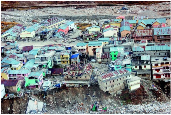
Joshimath is Sinking

Joshimath, a key transit point for tourists traveling to Badrinath and Hemkund Sahib, situated at an altitude of 1,890 metres from sea level in the Garhwal Himalayas, has a population of over 20,000. ft is located on the Rishikesh· Badrinath National Highway (NH-7) of Chamoli district which falls in Zone V of the Seismic Zonation map and almost sits on the tectonic fault line of Vaikrita Thrust (VT). What really made things worse is the weak foundation of the city. Sitting atop a glacial moraine, which are distinct ridges or mounds of debris that are laid down by a glacier, the town’s foundation has no solid rocks. These sediments have voids. making them extremely unstable. geologically. Spread over an area of 2,458 square kilometers, Joshimath is one of the six tehsils (blocks) in Uttarakhand’s Chamoli district. Previously, many incidents like landslides, subsidence or sinking and flash flood occurred in and around Joshimath city and multiple major and minor cracks also exposed on roads. walls und floors of houses. From 11 January 2023, major portion of Joshimath city started to sink continuously and major and minor cracks began to appear on roads, floors, ceilings and walls of houses. Around 1000 people have been evacuated from the unsafe area and risky buildings (Biswajit et al., 2023). The place was sitting atop with a disaster of this magnitude waiting to happen, but administration could not assess it. The Joshimath town is situated along a narrow gorge at the confluence of two major rivers: Dhauliganga and Alaknanda and is close to the Main Central Thrust (MCT) fault passing through on the southern side of town. So, it is prone to earthquake and also frequent rainfall. (YaspalSundriyal et al.,2023). The reactivation of these fault lines nearly 50-60 kilometers under the surface remains a big mystery. There are many contributory factors leading to the imbalance in the hill ecosystem but chiefly among them are the rapid rise in construction activities, widening of the Char Dham Yatra road and the National Highway 7, which runs through the town taking tourists and cargo to the holy shrine of Badrinath every year Joshimath’s problems with slope instability have given worse as a result of unplanned construction that didn’t take bearing capacity into account (USDMA. 2022). The widening of the road brought more and more hotels springing up in and around Joshimath therefore, religious tourism also spiked. Prime minister’s visit to Kedarnath and Badrinath joined a record number of 41 lakh pilgrims that thronged the shrine thereby causing an immense pressure on the natural resources which was unsustainable at any point of time. The roads in the geologically sensitive region should have been five meters wide, but the government widened the roads to 12 meters in a complete disregard to the Ravi Chopra committee recommendations. This led to not only cutting around 50000 trees but also more and more cleaning of the hills. This made the already ecologically sensitive region highly vulnerable to landslides as the top layer was cleaned for the road construction. Another factor which was extremely important in destroying the local hill ecosystem was the establishment of Tapovan-Vishnugad hydeI project which mandated NTPC to carve out a 12 kilometre tunnel puncturing some of the acquirers in the process. However, due to the unavailability of solid rocks underneath, the water released from the acquirers seeped into the soil and loosened it from within. With the top surface of the soil already gone due to intense- construction, the region stood on the edge and sunk as the time passed on. That is not all. In the last decade:, the ridge that houses Joshimath has been traversed by running streams with a high gradient from Vishnuprayag, a confluence of the Dhauliganga and the Alaknanda rivers. The confluence has survived two big glacial and cloud outbursts that deposited heavy sediments causing major erosion in the region. The outbursts brought debris worth 10,000 houses in one day, which made things worse for Joshimath.
Read more...